naptu2: [size=14pt]The Bakassi Story - Part 1[/size]
By
Nowa Omoigui
nowa_o@yahoo.com
1. When the Obong of Calabar signed a "Treaty of Protection" with Britain on September 10, 1884 Britain agreed to "extend its protection" to the Obong and his Chiefs. The Obong agreed and promised to refrain from entering into any agreements or treaties with foreign nations or Powers without the prior approval of the British Government. That is, he signed away his Kingdom as a British protectorate. This type of subterfuge was carried out with many of our ancestors. All of this was before "Nigeria" was created. Note too that unlike agreements between metropolitan powers these so called protectorate agreements with African Kingdoms did not have precise definitions of boundaries. On November 15, 1893, Britain and Germany defined their boundaries in Africa, supplemented by another agreement on March 19, 1906. These covered British and German Territories from Yola to Lake Chad.
2. In 1900, 1903 and 1906, key declarations made - and militarily enforced - which created the colonies of 'Northern Nigeria' and 'Southern Nigeria' (inclusive of the Colony of Lagos). The Obong of Calabar was neither consulted nor did he resist. This was all conducted between metropolitan powers and they understood what they were doing. "Protectorates" became "Colonies". Note the difference.
3. In 1913, Britain - for the colonies of "Southern" and "Northern" Nigeria - and Germany - for "Kamerun" - reached an agreement on their border from Yola to the Sea. The first of these agreements was signed in London on March 11, 1913 titled: "(1) The Settlement of the Frontier between Nigeria and the Cameroons, from Yola to the Sea and (2) The Regulation of Navigation on the Cross River". The second was signed at Obokum on April 12, 1913 by Hans Detzner, representing Germany, and W. V. Nugent, representing Britain. It addressed the precise demarcation of the Anglo-German Boundary between Nigeria and Kamerun from Yola to the Cross River. There were eight accompanying maps.
For Bakassi (also spelled Bakasi) peninsula in particular, the Germans were interested in shrimps and an undertaking that Britain would not seek to expand eastwards. The British were interested in uninterrupted and secure sea lane access to Calabar, a key trading post. Since the Germans already had the option of using Douala environs as a port, they conceded the "navigable portion" of the offshore border to Britain. In exchange, Britain conceded the Bakassi peninsula proper to Germany. In other words, to get Germany's cooperation not to threaten access to Calabar, Bakassi peninsula was conceded by Britain. The Obong did not resist. Note that "Nigeria" did not yet exist. This was long before General Gowon was born.
4. In January 1914, "Nigeria" was created by amalgamation. Neither the Obong nor any other traditional ruler, Emir, or Chief anywhere in "Nigeria" was consulted about it let alone its borders. As was the practice then, it was done for British economic reasons - to extend the railway system of "Northern Nigeria" to the sea and to use excess tax revenues - derived from spirits - from "Southern Nigeria" to correct a budget deficit in "Northern Nigeria". British and German maps of "Nigeria" from January 1914 clearly show Bakassi peninsula in Kamerun. There was no resistance from the Obong of Calabar or his people or any other native "Nigerians" for that matter.
5. The First World War broke out in 1914. In 1916, Britain invaded German Kamerun. Among the Nigerian troops and carriers fighting for Britain were natives of Nigeria, including some from present Cross- River State. At the end of the war, all German territories were divided between France and Britain by the Treaty of Versailles. The League of Nations placed them under British or French mandate. The boundaries between British and French mandated Kamerun was defined by the Franco-British Declaration of July 10, 1919 by Viscount Milner, the British Secretary of State for the Colonies, and Henry Simon, the French Minister for the Colonies. In this agreement Bakassi and the rest of what became known as "British Cameroons" were placed under British mandate and administered coterminous with "Nigeria" but not actually merged. The old 1913 border was retained. To codify this further, another agreement was signed December 29, 1929 and January 31, 1930 between Sir Graeme Thomson, Governor of the Colony and Protectorate of Nigeria, and Paul Marchand, Commissaire de la République Française au Cameroun. This Declaration was ratified and incorporated in an Exchange of Notes on January 9, 1931 between the French Ambassador in London and the British Foreign Minister. Again, maps from that period show the Bakassi peninsula within "British Cameroons", not the "Colony and Protectorate of Nigeria". Neither the Obong nor his people, nor any other "native Nigerians" protested. General Gowon was born a few years later.
6. The Second World War broke out in 1939. Native Nigerians also fought for Britain. After the war, the British and French League of Nations mandates over the Southern and Northern Cameroons and Cameroun were replaced by trusteeship agreements under the new United Nations - approved by the General Assembly on December 13, 1946. These UN agreements re-ratified the prior borders as codified by the previous Anglo-German and Anglo-French agreements. Maps from that period show Bakassi peninsula in the Cameroons, not the real Nigeria.
7. On August 2nd, 1946 Britain divided the Cameroons into two, called "Northern Cameroons" and "Southern Cameroons". The 1946 'Order in Council' contained detailed provisions describing the border separating these two regions, now conveniently administered from colonial Nigeria - but not part of it.
8. In 1954, the Secretary of State for the Colonies issued a legal order defining the border between Nigeria's "Eastern region" and the "Southern Cameroons". Bakassi Peninsula was in the "Southern Cameroons", distinct from the Eastern region and the Calabar province and maps from that period show this very clearly. General Gowon had not yet joined the Nigerian Army. Neither the Obong nor his people nor any other native Nigerians protested.
9. In March 1959, the UN asked Britain to clarify the wishes of the people living in Northern and Southern Cameroons trusteeship territories in the run up to the "independence" of Nigeria and Cameroun. Maps from that period show Bakassi peninsula in the Cameroons, not the real Nigeria.
10. On January 1st, 1960 the French Cameroons became independent. Instruments creating the new country and exchange of notes between France and Cameroun rehashed all its colonial boundaries as defined by previous colonial agreements.
11. On October 1st, 1960, Nigeria became independent. Instruments creating the new country and exchange of notes between Britain and Nigeria rehashed all its colonial boundaries as defined by previous colonial agreements. Maps dated 1960 show that the Bakassi peninsula was clearly within the "Southern Cameroons", not "Nigeria proper." General Gowon was only a subaltern at the time.
12. On February 11th and 12th 1961, a plebiscite was held to " clarify the wishes of the people living in Northern and Southern Cameroons ". The population of Northern Cameroons had earlier - in 1959 - "decided to achieve independence by joining the independent Federation of Nigeria", while the population of Southern Cameroons, whose plebiscite could not be done in 1959 for security reasons, now "decided to achieve independence by joining the independent Republic of Cameroon" (General Assembly resolution 1608 (XV) of 21 April 1961). Note that there were 21 polling stations on the Bakassi peninsula itself and that 73% of the people living there voted to "achieve independence by joining the independent Republic of Cameroon". (Note the blunder here. By spelling it as "Cameroon", rather than "Cameroun", the UN created an opening for the people of the "Southern Cameroons" to say they never voted to join "Cameroun" which is the former French territory.
13. In 1962, the government of Tafawa Balewa exchanged diplomatic notes with Cameroun acknowledging the fact that Bakassi was not Nigerian territory. General Gowon was a T/Captain. Maps from that period show Bakassi peninsula in Cameroun, following the results of the 1961 plebiscite.
14. In January 1966, Major General Ironsi came to power in Nigeria. He committed his government to respect all prior international agreements made by the Balewa government. Maps from that period show Bakassi peninsula in Cameroun.
15. In July 1966, then Lt. Col. Gowon came to power in Nigeria. He too committed his government to respect all prior international agreements made by the Ironsi and Balewa governments. Maps from that period show Bakassi peninsula in Cameroun
16. In 1970, moves began to be made by independent Cameroun and post-civil war Nigeria to clarify their maritime border which was vaguely defined by the 1913 Anglo-German Treaty. Maps from that period show Bakassi peninsula in Cameroun, but the offshore boundary was unclear since there was no detailed demarkation of the "navigable portion" of the approach channel to the Calabar estuary. Then Attorney General Elias correctly advised the Gowon government that post-colonial Nigeria had no legal basis for contesting the Bakassi peninsula itself, but that work to delimit the offshore boundary and vague sections of the land boundary should proceed at full speed in accordance with the original Anglo-German Treaty of 1913. The technical problem thus became deciding exactly what part was "navigable" and what was not. It is this matter that was addressed on April 4th, 1971 at Yaoundé when Nigeria's General Gowon and Cameroun President Ahidjo, accompanied by large delegations, signed the "Coker-Ngo" Line on British Admiralty Chart No. 3433 "as far as the 3-nautical-mile limit." The status of the Bakassi peninsula proper was not an issue for discussion. Maps from that period show Bakassi peninsula in Cameroun.
17. On June 1st, 1975, Gowon and Ahidjo signed the Maroua Declaration for the partial extension of the 1971 maritime boundary. Again, the status of the Bakassi peninsula proper was not even an issue for discussion. Maps from that period show Bakassi peninsula in Cameroun.
18. On July 29, 1975 General Gowon was overthrown by General Murtala Muhammed. One of the first acts of that regime was to begin to question all the domestic and foreign policy decisions made by General Gowon - including the offshore maritime border with Cameroun. In the rush to smear Gowon publicly, he was held accountable for "giving away Bakassi" - an event that had actually occurred before he was born. Muhammed's decision to renege on Gowon's agreements with Ahidjo resonated with a section of the population which had been hoping for a way to get out of its commitments to Cameroun deriving from the 1961 plebiscite and the colonial heritage dating back to 1884. Still, Nigerian official maps from that period and continuing till today except a few that were reprinted on orders from the Babangida government in 1991 show Bakassi peninsula in Cameroun.
19. The rest of what transpired in 1981, 1994, 1996 and since then is well known - including General Abacha's moves to formally create an administrative set up there and all the military clashes.
20. On October 10, 2002 the International Court at The Hague confirmed what Elias had said in 1970 and reiterated almost a century of colonial agreements which had repeatedly placed Bakassi peninsula inside Kamerun/Cameroon/Cameroun. It also went further to provide guidelines for the final clarification of the offshore border - which if anything, is the only issue about which General Gowon, acting on advice from some civil servants, may not have been as aggressive as he could have been. But even that is a matter of technical detail, not treason.
Post-script: On September 3, 2002 a few weeks to the Judgement of the ICJ, Chief R Oluwole Coker, the Nigerian Surveyor who, along with Mr. Ngo of Cameroun decided the "Coker-Ngo" offshore line of 1971, which Gowon and Ahidjo signed, died. May his soul rest in peace.
http://www.dawodu.com/bakassi2.htm 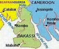
|
naptu2: [size=14pt]The Bakassi Story - Part 2: [/size]
1950-75
By
Nowa Omoigui
Nowa_o@yahoo.com
In the first installment titled "The Bakassi Story", we reviewed a very brief summary of the history of the dispute starting from the Treaty between England and Old Calabar in 1884 all the way through to the ICJ judgement of October 10, 2002. Those who want more information about the fall of Calabar should consult “Politics and Society in South Eastern Nigeria” by KK Nair or “Old Calabar 1600-1891” by AJH Latham. A nice summary is available in “The Fall of Nigeria – The British Conquest” by Obaro Ikime (Heinemann, 1977). In Part 2, we shall focus more specifically on the twenty-five-year period from 1950 to 1975.
COUNTDOWN TO THE UN PLEBISCITE
1949 – 1954
As we noted previously, following the Second World War, League of Nation mandates were replaced by UN mandates. Dr. E. M. L. Endeley became President of the Cameroon National Federation in 1949. At that time southern Cameroons (including Bakassi peninsula) was administered with Nigeria. Following a dispute within the Eastern House of Assembly in Enugu in May 1953, nine out of thirteen delegates from the Southern Cameroons, who had originally been elected on the platform of the National Council for Nigeria and the Cameroons (NCNC), opted for ‘neutrality’, claiming that they were not Nigerian. Mr. S. T. Muna, the only Southern Cameroonian in the Eastern Executive Council at that time was actually dismissed. This crisis led to the name change from “National Council for Nigeria and the Cameroons”, as the NCNC was then known, to “National Council of Nigerian Citizens.“
During the July 1953 London Constitutional Conference, Endeley, citing fear of “Nigerian domination”, requested the unconditional withdrawal of the Southern Cameroons from the Eastern Region of Nigeria, and its transformation into a separate region of its own in line with its trusteeship status. Britain agreed and implemented separation in 1954, making the Southern Cameroons (including Bakassi peninsula) a semi-autonomous quasi-region of the Nigeria Federation with its own House of Assembly and Executive Council located at Buea. Endeley was called the Leader of Government Business, not Premier, primarily because Southern Cameroons was not yet a full region. Importantly, the Bakassi peninsula which was part of Kamerun/Cameroon since 1913, as inherited in the league of Nations mandate after World War 1, was also excised from co-administration with the eastern region along with the rest of the southern Cameroons at that time. There is no evidence that anyone made an issue of the matter then (Nigeria Gazette No. 53 vol. 41, B389-408; [D440-59]).
1955 – 1960
In 1955 there was a split in Endeley’s party which was then allied with the Action Group (AG) and John Ngu Foncha emerged as his rival on the platform of the new Kamerun National Democratic Party (KNDP). This party’s goal was complete secession of southern Cameroons from Nigeria and eventual reunification with Francophone Cameroun. Endeley was accused of abandoning his former stance of pro-unification in favor of integration with Nigeria. At about the same time the Union des Populations Camerounaises (UPC), a Bamileke based radical leftist party in Francophone Cameroun led by Felix Moumie was being banned by the French Governor. As they fought a bitter and violent guerrilla war against ruthless French troops, they would often cross over to Bamileke sections of British Cameroons (i.e. “Nigeria”) for sanctuary.
In mid 1957, there was a Constitutional Conference in London to resolve issues preparatory to Nigeria’s independence which was initially proposed for a date in 1959, but "not later than April 2, 1960." In August that year, Tafawa Balewa became Premier in an All Nigeria Federal Executive Council. Among the first three Federal Ministers from the Eastern region was a gentleman called Okoi Arikpo. He would later feature in the post-independence Gowon government.
On September 25th the Willink Commission was set up to deal with the case of Nigerian minorities. Interestingly, no submission was made to the panel regarding the case of Bakassi peninsula, considered then to be part of southern Cameroons. The Willink report was published in October 1958 – recommending against the creation of new regions in Nigeria. Shortly thereafter the Constitutional conference resumed in London – and once again the Bakassi issue was not discussed, nor was the status of Calabar as a former “protectorate” rather than “colony” as some have said, an issue.
In the January 1959 southern Cameroons election (in which Bakassi residents participated), Endeley was voted out of power and replaced by Foncha, a man with even less disguised anti-Nigerian instincts. In October that year, the Enugu based 1st Queens Own Nigeria regiment (1QONR) was temporarily deployed to southern Cameroons for “Training”. However, Bamileke UPC sympathizers in Bamenda viewed this as a counter-insurgency deployment in support of the hated French colonial administration. In early 1960, responding to more violence in the area, the 1QONR again returned to Bamenda area in full force, followed shortly thereafter by the 4QONR from Ibadan who were deployed further south to Kumba near the coast. The 5QONR and 3QONR later replaced both battalions respectively – followed later by the 2QONR. These shows of military force did not endear Nigeria to certain opinion leaders in the local population.
On October 1, 1960 Nigeria became independent. Our first Prime Minister, Alhaji Tafawa Balewa signed an exchange of notes with the United Kingdom saying (inter alia), that
“….it is the understanding of the Government of the United Kingdom of Great Britain and Ireland that the Government of the Federation of Nigeria agree to the following provisions:
“(i) all obligations and responsibilities of the Government of the United Kingdom which arises from any valid international instrument shall, henceforth, in so far as such instrument may be held to have application to Nigeria, be assumed by the Government of the Federation of Nigeria.
(ii) the rights and benefits heretofore enjoyed by the Government of the United Kingdom in virtue of the application of any such international instrument to Nigeria shall henceforth be enjoyed by the Government of the Federation of Nigeria……..”
By customary international law, therefore, “Nigeria” inherited (and agreed without question) all the present international boundary regimes of Nigeria – with Dahomey (Benin), Niger, Chad and Cameroon - as originally defined by various colonial Anglo-French and Anglo-German Treaties. Therefore, the southern Cameroons (inclusive of the Bakassi peninsula), which was now under separate direct British rule as a trusteeship territory, asked Nigerian troops to leave. A British Battalion replaced them.
However, 1QONR, supported by the new Recce Unit of the newly independent Nigerian Army were then deployed in an internal security precaution along the frontier to prevent spill-over of violence. The old Anglo-German border of 1913 was resurveyed at this time by Nigerian military foot patrols to confirm the location of old beacons and new Police Posts were constructed along it for clarity. [NJ Miners: The Nigerian Army 1956-1966, Methuen 1971, page 73-74]
It was against this background that most southern Cameroonians favored self-determination – independent of BOTH Nigeria and Francophone Cameroun. However, conflicting interests on the international scene subverted their political will. The pan-Africanist movement, led by Nkrumah, for example, was opposed to the emergence of small African states. Britain was initially afraid that an allegedly economically unviable “Southern Cameroons” would be an albatross around its taxpayers and thus preferred that it join with large Nigeria next door. Although southern Cameroonian leaders preferred that the plebiscite provide a simple choice between "integration with Nigeria" or "secession and independence", the UN imposed different questions on the electorate. In October 1959, General Assembly Resolution 1352 XIV, composed the choices as follows:
(I) Do you wish to achieve independence by joining the independent Federation of Nigeria?
or
(II) Do you wish to achieve independence by joining the independent Republic of Cameroun?
However, popular opposition to these choices compelled both Foncha and Endeley to request that southern Cameroons simply be granted independence. Initial momentum in this direction and talks in London in November 1960, however, collapsed in acrimony and the UN had its way. In the countdown to the plebiscite, reunification with Francophone Cameroun was marketed by well-funded Francophone groups as a loose union in which the Southern Cameroons would maintain self-rule. The most prominent among these pro-unification forces were elements of the Bamileke tribe who was split by the post-World War 1 partition into British and French territories. Its own arrangements for independence in 1960 and infighting among its leaders in the meantime distracted Nigeria, following the controversial federal elections of 1959.
Simultaneously, the refusal of Britain to create new regions for ethnic Nigerian minorities at the London constitutional talks of 1958 made it easy for pro-unification forces in southern Cameroons. They mischievously advertised integration with Nigeria as a reunion with the Eastern region from which it had “broken away” in 1954. The effect of this was amplified by short-sighted Nigerian politicians who were afraid that the integration of southern Cameroons would provide the eastern region based NCNC with a larger geographic and political base in the tri-regional rat race to control Nigeria.
THE PLEBISCITE
In October 1961, therefore, following the UN Plebiscite of February 11th, the Southern Cameroons (including the Bakassi peninsula) was federated with the Republic of Cameroun, while the Northern Cameroons joined Nigeria [http://www.iupjournals.org/africatoday/aft47-2.html]. Thus, by default, and by plebiscite, the Nigeria-Cameroun boundary in the south - as described by the Section F of the Legal Notice 126 of 1954-58 - and clearly marked with resurveyed 1913 beacons, reverted to the old Anglo-German border which antedated Nigeria's amalgamation (http://www.gamji.com/nowa46.htm). An Anglo-French treaty following the partition of German Kamerun after World War 1 specified the portion in the North.
The results of the plebiscite in the North were heavily influenced by the single-mindedness, leadership and strategic genius of the Sardauna of Sokoto, the late Alhaji Ahmadu Bello, assisted by Mr D.J.M. Muffett, then Resident General in the Northern Cameroons. Cameroun reacted unfavorably to it and even went to the ICJ to file a complaint that voting was irregular. However, the complaint was not sustained. The results in the south reflected personal, ethnic and political rivalries within southern Nigeria and Cameroon, confusing interpretation of the plebiscite questions on the part of villagers, background influence from Francophone interests, and failure of the Nigerian intelligentsia and government to appreciate the strategic implications of what was going on. It would prove to be a costly oversight down the road.
Nevertheless, Nigeria, perhaps not wanting to rock the boat, having successfully staved of Cameroun’s challenge to the northern Cameroons plebiscite, voted at the UN to approve the results of the southern Cameroons plebiscite, oblivious to certain subtle issues of legality, due process and self-interest that were lurking in the background. Never too comfortable with the idea, but thinking it could win autonomy, anglophone Southern Cameroon (along with Bakassi in the southwestern district) departed on an uncertain journey to its future with Francophone Cameroun.
1962
In 1962, Nigeria confirmed its approval of the results of the plebiscite in a Diplomatic Note No. 570 of March 27, 1962 to Cameroun, which included a map showing Bakassi in the newly unified Cameroun. From then on, until the 1990s Nigeria would have no serious administrative or military presence in the peninsula. [Even the much-touted ‘Bakassi local government’ was only created in 1997, a full three years AFTER the case at the ICJ had begun]. During the first republic, in addition to the Embassy in Yaounde, however, Nigeria opened a consulate in Buea, capital of the Southern Cameroons - now Western Cameroun. Presumably this was in recognition of the large number of Nigerians living in the region, even after the plebiscite.
ORGANIZATION OF AFRICAN UNITY (OAU)
1963
In 1963, the Organization of African Unity (OAU) was established. Article III, paragraph 3 of the founding Charter states: "Respect for the sovereignty and territorial integrity of each state and for its inalienable right to independent existence." Nigeria ratified this Charter.
1964
In 1964, Nigeria approved the Cairo Declaration of the Organization of African Unity of July 1964, committing African States to the inviolability of colonial borders. Specifically, AHG/RES 16(1) states: "Solemnly declares that all Member States pledge themselves to respect the borders existing on their achievement of national independence." Nigeria ratified this declaration, and by implication restated its commitment to the Nigerian-Cameroun colonial border, as it had done in 1960 (Exchange of Notes with the UK) and again in 1962 (Diplomatic Note 570).
BOUDAN AND DANARE DISPUTE
1965
In 1965, a number of border incidents took place between two villages - Boudan and Danare - near Ikom, in a forested area of the old boundary. A joint Nigeria-Cameroun boundary demarcation team was set up and sent to the area. The late Surveyor O.A. Aqua as well as Surveyor Dennis Mbata represented Nigeria. Cameroun was represented, among others by late Surveyor G. Obenson (who later became a Professor at the University of Lagos). As had previously been confirmed in 1960, the area was well demarcated by the colonial administration (based on the 1913 Treaty) but the beacons were too far apart. Thus the purpose of the exercise was to place intervisible beacons along the old 1913 boundary. This exercise was suspended on account of the military coup of January 1966 - and never resumed until after the civil war.
NIGERIA IN CRISIS
1966
In late 1966, in the tense circumstances following the northern counter-rebellion of July 29, a plane carrying weapons - allegedly ordered by Eastern region Military Governor Lt. Col. Ojukwu - and headed for Enugu in Nigeria's eastern region crashed over the Cameroun mountains. It remains unclear to this day whether the crash was accidental or the plane was shot down. But Cameroun's President Ahidjo, who was not informed beforehand of the flight's planned overpass through Camerounian air space, was highly irritated and embarassed. He would, from that point onwards, view the Ojukwu leadership in Eastern Nigeria - and later Biafra - with suspicion.
1967
After the events of late 1966, but before the civil war actually broke out, Douala airport in Cameroun was a favorite destination of foreign-based Ndigbo returning to the Eastern region. It was also a favourite route for getting out of Nigeria until the border areas were partially secured by federal Nigerian Troops during the war. In late May 1967, following the mandate granted to Lt. Col. Ojukwu by the Eastern Consultative Assembly to secede Lt. Col. Gowon created 12 new States in Nigeria - including the South-Eastern State headed by Major U. J. Esuene, an Ibibio officer in the Air Force. The creation of the South-Eastern State from the former eastern region was not unnoticed across the border and was a factor in rekindling interest in rejoining Nigeria among Efik and Ibibio residents of Bakassi peninsula - many of whom had actually voted in 1961 not to pursue integration with Nigeria. Indeed, Nigeria's Consul-General at Buea, SJ King, transferred from the foreign service to his home South-Eastern State where he later became the Permanent Secretary.
CALABAR SECTOR DURING THE CIVIL WAR
In July, the Nigerian Civil War broke out - and lasted until January 1970. During the war, both Nigeria and Biafra were in an international rat race for support and recognition. Nigeria lobbied its neighbors to prevent Biafra from using their territory as either a staging point for military operations or through-put for weapons supply. Very early in the campaign a decision was made to create a vise around Biafra by attacking simultaneously from the North and the sea. During operations to take Calabar on October 17 - 19, the threat of the Bakassi peninsula being used to outflank and surprise the Nigerian task force and dominate the approach channel to the Calabar estuary became an issue, necessitating more specific diplomatic exchanges with Cameroun to clarify its intentions. In fact, troops of the 12 Brigade, 3rd Marine Commando under Major (later Lt. Col.) R. Aliyu, reporting to Colonel (later Brigadier) B. Adekunle, supported by naval and air bombardment, could not break out from Calabar for almost a month, only barely holding on to the town.
Major Ogbo Oji of the 9th battalion, 52 Biafran Bde, initially led the Biafran resistance at Calabar (until he was badly wounded). The Brigade had no Commander after Colonel Eze was removed in curious circumstances (Madiebo: The Nigerian Revolution and the Biafran War, Fourth Dimension Publishers, 1980). Lt. Col. David Okafor who was later reinforced by Lt. Col. Adigio of the 7th battalion replaced Oji. They were both later replaced - in controversy - by Majors Odigwe and Omerua under a newly formed 56 Brigade under Lt. Col Festus Akagha who had barely escaped - in controversial circumstances - from the Midwestern theater. European mercenaries later took over that front. To show its importance to Biafra, nearly all-available ammunition - which was never enough to begin with - was sent to that front. Nigeria got assurances from Cameroun that the Bakassi peninsula - which Nigeria had acknowledged as far back as 1962 was in Cameroun and, therefore, outside its control - would not be used by hostile elements. This pre-empted contingency plans for "hot pursuit" operations across the border and safeguarded the rear as federal troops slowly pushed east of the Cross river against initially determined Biafran troops who, nevertheless, were eventually undermined by internal conflicts within the Biafran political, administrative and military structure.
The federal plan was to link up through Oban with 1st Division federal elements coming down from Ikom against Biafran forces led by Lt. Col. Ochei. The objective was to cut off the Biafran border point with Cameroun at Ikang. This was finally achieved in December. However, the road to Ikom along with the towns of Ikot Okpara, Amolo Water Town, Mbabu Owa and Agobi-Iwolo were not taken until the end of January 1968, courtesy of a controversial Biafran withdrawal ordered by European mercenaries hired by Ojukwu. Note that in his book "My Command" written by General Obasanjo (rtd) and published by Heinemann in 1981, all the maps of that sector show the Bakassi peninsula in Cameroun (page 93). In his book “The Struggle for Secession, 1966-1970. Frank Cass, 1971” N.U. Akpan, the Secretary to the Eastern Regional and later Biafran government, who is himself of South-Eastern origin, also shows the Bakassi peninsula in Cameroun in a map titled “Map of Eastern Nigeria declared Biafra, 30th May, 1967” (page 20). The war did not begin until July 6th.
THE POLITICAL LEADERSHIP OF CAMEROUN AND ITS ATTITUDE TO THE NIGERIAN WAR
Late President Ahmadou Ahidjo of Cameroun was a Fulani man whose father was originally from Kano in Nigeria. His mother was from Garoua in Cameroun. In fact Ahidjo grew up around Yola and Mubi in Nigeria and was a playmate of Senator Iya Abubakar. His former District Head in Nigeria, Ambassador Malabu, was made Ambassador to Cameroun to cement the relationship. It is said that every time late Alhaji Ahidjo saw late Alhaji Malabu he would genuflect. Thus, Nigeria gained and sustained Cameroun's support during the civil war, not by territorial concessions as have been widely and wrongly reported, but by manipulating primordial links between Ahidjo and Northern Nigeria.
In addition, Ahidjo and key elements in the francophone Cameroun bureaucracy were afraid of the effect - on southern Cameroons - of a precedent for secession by supporting Biafra. It was not a secret that southern Cameroons had always preferred self-determination. They were also in possession of french intelligence reports that Biafra would someday annex the former Southern Cameroon along with Fernando Po in a swath of territorial acquisitions in the area of the "Bight of Biafra". Adult male Ndigbo living in Cameroun at that time were, therefore, required every Saturday to report to designated open fields and kept there for many hours before being released by Police. In this manner Ahidjo kept a tight reign on their movements and threw them off balance. Not to report usually led to unwelcome domestic visits by Cameroun gendarmes. In supporting Biafra, France was interested in breaking up Nigeria, the large threatening anglophone nation-state, but was not interested in the balkanization of Cameroun which it, therefore, kept discreetly informed of goings on inside Biafra. Such "intelligence" and "rumors" about alleged future Biafran intentions, were never actually officially confirmed by anyone but it played into old rivalries in the NCNC and Eastern region going back to the days that Southern Cameroons was administered alongside Nigeria as a Trusteeship territory.
1968
Equatorial Guinea, the country across from and next to Nigeria and Cameroun in the Gulf of Guinea gained independence and supported the federal side in the Nigerian civil war. The immediate effect of this was the termination of relief flights to Biafra.
1969
In 1969 a "Boundary Section" was established in the Federal Survey Department of the Nigerian Federal Ministry of Works. The surveyor who was asked to run the office as "Head of Boundaries", arrived from outside Lagos to find that the rooms allocated to him had no chairs or desks. That was the level of importance that "Boundaries" was given. No one knew then that Nigeria would in due course be consumed by a bitter international boundary dispute, not to mention all the domestic ones. Needless to say that the boundary section soon became the databank, particularly for Nigeria’s International boundaries and later for internal boundaries.
POST-WAR ISSUES
1970
After the war, General Gowon of Nigeria – with Ahidjo’s support - decreed that the name “Bight of Biafra” be removed from maps of the Gulf of Guinea close to the Nigeria-Cameroun-Equatorial Guinea border area. It was renamed “Bight of Bonny”.
Issues raised by wartime policing of the border to prevent infiltration and exfiltration resurrected the old quest to clarify the boundary. It was amplified by reports that Cameroun had been exploring for Oil along the undemarcated maritime border between both countries while Nigeria was busy fighting its civil war. A meeting of the Nigeria-Cameroun Boundary Commission, therefore, took place at Yaounde, Cameroun from August 12-14. The Nigerian Ambassador as well as the Cameroun Foreign Minister opened the meeting. However, they both subsequently left and ceded authority to technical experts from the Surveys, Fisheries, Navy, Immigration, Justice, External Affairs, Cabinet Office etc. departments of both countries. The most senior Nigerian civil servant present who thus led the delegation was Chief R. Oluwole Coker, Director of Federal Surveys. The SouthEastern State (now Cross-River and Aqua Ibom) was strongly represented by technical and legal experts from the State Government. Neither General Gowon nor Alhaji Ahidjo was present.
Although the draft agenda submitted by Nigeria for consideration included fresh physical and administrative considerations for delimiting the boundary, after considerable deliberation, the joint commission agreed to use the 1913 Anglo-German Treaty. The South-Eastern delegation for instance, had initially brought cartons of tax receipts paid by residents of Bakassi area to the Nigerian government as a way to make a claim over the peninsula. However, it later became apparent that the same residents also paid taxes to the Cameroun authorities. Many had homes on both sides of the border. They even had fishing villages with precisely the same name on both sides of the border.
Eventually, both sides agreed to demarcate the border in three sectors, beginning with the maritime sector.
When the Nigerian delegation got back to Nigeria, interested parties, unsatisfied with the decision to use the 1913 Treaty as the legal paradigm (and unaware that the Balewa government had long settled this issue), approached the Foreign Minister, Dr. Okoi Arikpo. Arikpo, a sophisticated anthropologist and lawyer, who was himself from South-Eastern state, asked then Attorney General Teslim Elias for a formal legal opinion on the matter to guide him in making recommendations to the Head of State, General Yakubu Gowon. The Nigerian Mission at the UN was also contacted to clarify whether residents of the Bakassi peninsula had taken part in the 1961 plebiscite. On September 3rd, 1970 Teslim Elias, Nigeria's Attorney General who was also a Professor of Law at the University of Lagos and former academician at Oxford University, wrote his landmark legal opinion [http://www.gamji.com/nowa43.htm]. Unambiguously, he stated "This Ministry has given a most careful consideration to the whole question in the light of all the available evidence, and the conclusion is that there is no legal basis for Nigeria’s claims to the Bakasi peninsula for the reasons stated herein........According to the information received from the Federal Directorate of Surveys, the Bakasi Peninsula has never been included as part of Nigeria in the administrative maps of Nigeria since the then Southern Cameroons ceased to be part of Nigeria in 1961. Also, the Northern Region, Western Region and Eastern Region (Definition of Boundaries) proclamation 1954 (L. N. 126 of 154) showed the Bakasi Peninsula as forming part of the then Southern Cameroons. Moreover, by a Diplomatic Note No, 570 of March 27, 1962, from your ministry to the embassy of the Cameroons in Lagos, to which was attached a map prepared by the Federal Surveys, Nigeria recognized the Bakasi Peninsula as forming part of the Cameroons." Arikpo supported Elias and recommended that Gowon not pursue the peninsula itself as an issue during boundary meetings with Ahidjo. Gowon was advised to focus on the maritime border - as defined by the 1913 Anglo-German Treaty - whenever he eventually met with Ahidjo. That is what Gowon did.
Subsequently, the UN plebiscite report arrived from New York - accompanied by a ward and polling station map - showing villages in the peninsula as locations of polling stations during the 1961 plebiscite. In fact a majority of residents there voted - along with the rest of southern Cameroons - not to join Nigeria. This political information merely confirmed the legal views of those who felt the matter should not be pursued. (Note that there is no such thing as a “Bakassi Village”. Bakassi is an area. Without a map one would not know which villages fall where. In interpreting it, the migrant nature of the fishing settlements should also be noted.)
UNDERSTANDING THE 1913 TREATY AS A BASIS FOR NEGOTIATIONS
Once the Nigerian Ministry of Justice declared that the 1913 treaty was the legal context for boundary discussions with Cameroun, and the Ministry of External Affairs concurred, everything else was subordinated to that legal opinion. Therefore, I strongly advise readers who want to understand what transpired under Gowon, not to read this section without first reading the 1913 Anglo-German Treaty and reviewing a map.
[ http://coalter@sovereigngeographic.com/images/cameroon.pdf ]
Researchers in the Boundaries section of Surveys looking for technical guidance in interpreting the 1913 treaty searched many sources as well as Nigeria's National Archives Libraries for material. It turns out that then Dr. John R. Victor Prescott, now a Professor Emeritus at the University of Melbourne in Australia, used to be a Surveyor at Federal Surveys in Nigeria and later a lecturer in Geography at the University of Ibadan from 1956-61. He wrote a PhD thesis titled "The evolution of Nigeria's political boundaries", a copy of which was deposited at the University of Ibadan library. Most of the original PhD work can be found in the following book:
Prescott, J.R.V., 1971: The Evolution of Nigeria's International & Regional Boundaries 1961-1971. (B.C. Geog. Series No.13), Vancouver: Tantalus Research Ltd.
He had predicted that there would be considerable difficulty in determining the navigable channel of the Nigeria-Cameroun maritime boundary in accordance with the 1913 treaty.
According to a "Dictionary of Geography" published by the Oxford University Press, the german word "thalweg" (also written "talwec" or "talweg" refers to "the line of the fastest flow along the course of a river" which usually crosses and recrosses the stream channel. From a geological point of view it refers to "the line defining the lowest points along the length of a river bed or valley or subterranean stream". In other words, the deepest part of a river or channel or lowest point of a channel section is the thalweg. The thalweg affects the distribution of sediments in a river because it gathers sediments from the bank on one side and deposits them on the other side, forming point bars where the sediments are deposited. With time it may even change the course of the river. These principles explain why the 1913 Treaty contain the following provisions: refers to "the line of the fastest flow along the course of a river" which usually crosses and recrosses the stream channel. From a geological point of view it refers to "the line defining the lowest points along the length of a river bed or valley or subterranean stream". In other words, the deepest part of a river or channel or lowest point of a channel section is the thalweg. The thalweg affects the distribution of sediments in a river because it gathers sediments from the bank on one side and deposits them on the other side, forming point bars where the sediments are deposited. With time it may even change the course of the river. These principles explain why the 1913 Treaty contain the following provisions:
"XIX. Should the thalweg of the Lower Akwayafe, upstream from the line Bakasi Point-King Point, change its position in such a way as to affect the relative positions of the thalweg and the Mangrove Islands, a new adjustment of the boundary shall be made, on the basis of the new positions, as determined by a map to be made for the purpose.
XX. Should the lower course of the Akwayafe so change its mouth as to transfer it to the Rio del Rey, it is agreed that the area now known as the Bakasi Peninsula shall still remain German territory. The same condition applies to any portion of territory now agreed to as being British, which may be cut off in a similar way."
From the foregoing it is easy to see how the definition of a thalweg can be problematic, particularly if there are seasonal changes in the size of the river. During the dry season, for example, when water volume shrinks, the residual channel may be assymmetrically located away from the middle of the river valley. Indeed there is a case of a boundary river in Adamawa State which changed course. Because the specifications of the boundary at that point did not contain provisions for such an eventuality (as was written into the detailed negotiations for Bakassi peninsula), the Camerounians hurried to plant crops on the former riverbed to prevent it from redirecting itself. In the case of the Nigeria-Cameroun maritime border (based on the 1913 Treaty), the Akpa Yafe river is east of the Calabar Estuary into which both the Calabar and Cross rivers empty. It is a small river, which intersects with the Calabar estuary low down near where the estuary empties into the Gulf of Guinea. Ordinarily, if there is only one approach channel to the Calabar estuary and if the position of that approach channel does not change either seasonally or after major storms, a good way to determine the location of the channel is on the basis of morphology (to account for sediment shift). However, when one is dealing with a river per se, the thalweg or deepest continuous channel used by vessels is typically used to determine the boundary. A thalweg can also be used for an approach channel if there are dangerous shoal waters on either side of it.
When one combines the effect of three different rivers empptying into an estuary, however, the question of dominant flow enters the equation. The flow channels of the dominant rivers (Calabar and Cross) shift that of the smaller river (Akpa Yafe) away. Thus, the true thalweg of the Akpa Yafe is very close to the banks of the Bakassi peninsula. The British knew this when they specified in the 1913 treaty that
"XXI. From the centre of the navigable channel on a line joining Bakasi Point and King Point, the boundary shall follow the centre of the navigable channel of the Akwayafe River as far as the 3-mile limit of territorial jurisdiction. For the purpose of defining this boundary, the navigable channel of the Akwayafe River shall be considered to lie wholly to the east of the navigable channel of the Cross and Calabar Rivers."
In fact, as far back as 1907 the Germans had requested for the frontier to be continued out to sea after reaching the mouth of the Akwa Yafe, all the way to “the middle of the channel of the mouth of the Old Calabar River”. The British, (according to minutes made by a colonial official by the name Strachey) refused this request and told the Germans the line should follow the shore of the Bakassi peninsula along the thalweg of the Akwa Yafe when the actual mouth of that river was reached. In exchange for not insisting on the impingement of the Calabar river channel the British agreed to abrogate Article 3 of the old Anglo-German agreement of April 14, 1893 which had prevented the Germans from establishing trading settlements on the Bakassi peninsula proper.
For those interested, a detailed discussion of tidal waters can be found in the book: " 'Water boundaries' by George M.Cole (1997) John Wiley: New York. ISBN 0-471-17929-9."
Changing Coastlines
Although it did not feature during the negotiations, the innocuous phrases in the 1913 Treaty, which read "XXI. From the centre of the navigable channel on a line joining Bakasi Point and King Point, the boundary shall follow the centre of the navigable channel of the Akwayafe River as far as the 3-mile limit of territorial jurisdiction." and "XXII. The 3-mile limit shall, as regards the mouth of the estuary, be taken as a line 3 nautical miles seaward of a line joining Sandy Point and Tom Shot Point" can potentially be controversial if taken out of context. As far back as 1903, European sailors had commented on the changing nature and position of the coastline. The exact location of the Bakasi, King, Sandy and Tom Shot points, therefore, were subject to change with time. In the days before Global Positioning System (GPS) Technology, the location of rivers and points was based on British Admiralty maps, updated at regular intervals. Any clarification with regard to the original treaty, therefore, would be meaningless if taken out of context of the original maps that accompanied the 1913 Treaty.
Committee of Experts
In October 1970, a joint meeting of the Committee of Experts from Nigeria and Cameroun took place in Lagos, Nigeria. It was a tough meeting that ended with no agreement on how to define the "navigable channel" of the Akpa Yafe river up to where it joins the Calabar estuary, particularly since no Admiralty map expressly delineated the navigable channel of the Akpa Yafe. On the Nigerian side, the Nigerian delegation took the position that the navigable channel of the Akpa Yafe river had to be seen to lie wholly east of the channel of the Calabar and Cross-Rivers - as was stated in the Treaty. Therefore, since the larger Calabar Estuary was bound to displace the flow of the smaller Akpa Yafe river eastward toward the Bakassi shore, the maritime boundary up to the 3-nautical mile limit had to be much closer to the Camerounian Bakassi coast than to the Nigerian Calabar Estuary coast. This is precisely what the British had originally intended when they signed the treaty with Germany in exchange for ceding the peninsula.
Unfortunately, though, the Head of Boundaries, who was nicknamed "The Hawk" by Okoi Arikpo, did not have the support of higher authority at Federal Surveys who felt that a compromise should be reached with Cameroun to allow negotiations proceed. This internal technical disagreement within the Federal Surveys - which would cost Nigeria several miles of maritime territory in the estuary and beyond - did not come to the attention of General Gowon until it was too late.
1971
In April 1971, there was a summit meeting of General Gowon of Nigeria and Alhaji Ahmadou Ahidjo of Cameroun in Yaounde. The Head of Boundaries did not attend the meeting. It was at this meeting that Gowon and Ahidjo agreed to define the navigable channel of the Akpa Yafe River up to Point 12. When Ahidjo asked his Camerounian survey expert to stop arguing and told Gowon to draw the line where he wanted it, Gowon turned to his own technical expert for guidance. The expert marked a point on the map and Gowon drew the line toward that point. Unfortunately, the line Gowon drew - on direct advice from the Director of Federal Surveys - was not the true navigable channel of the Akpa Yafe river. Not only did it run right into a ridge, the line criss-crossed the navigable channels of the Calabar and Cross rivers, which the British had intended (with German agreement) to be completely on the Nigerian side, west of the Akpa Yafe channel. See Article XXI "...For the purpose of defining this boundary, the navigable channel of the Akwayafe River shall be considered to lie wholly to the east of the navigable channel of the Cross and Calabar Rivers". Gowon and Ahidjo signed on both sides of the 3-mile line. The line is what is referred to in the ICJ judgement as the "compromise" line.
Excited that he had stared down Ahidjo and negotiated a good deal, Gowon returned to Nigeria initially unaware of the error.
Two months later in June, the Joint Boundary Commission met in Lagos, led by Chief Coker for Nigeria and Mr. Ngo for Cameroun. They extended the already faulty Gowon-Ahidjo "compromise line" outwards to sea in what is now known as the Coker-Ngo line. Among those in the delegation were honorable Justice Sam Endeley of Cameroun, Mr. SG Ukot, Permanent Secretary and Solicitor-General, South-Eastern State, Mr. Jemiyo, Principal State Counsel, Federal Ministry of Justice, Lagos, etc. The Head of Boundaries at Federal Surveys – who was not on the delegation for the Yaounde meeting - was back this time. Other prominent experts from the Federal and SouthEastern State civil services were also in attendance.
A few weeks later, following the signing of the Coker-Ngo line, murmurs of disapproval began filtering in through back channels and Gowon finally discovered what had transpired. Thereafter, the Director of Federal Surveys was not allowed to take part in Nigeria-Cameroun boundary negotiations until Gowon left office in July 1975. The Head of Boundaries took over his technical role as the principal government adviser at international summits involving both Heads of State.
In August, Nigerian experts, seeking ways to undo the damage visited Calabar and toured the area in a Survey ship carefully taking measurements and looking for low water marks based on certain provisions of the Law of the Sea.
1972
In May 1972, the joint boundary commission met, followed in August 1972 by a summit meeting at Garoua - hometown in Cameroun of President Ahidjo's mother. At Garoua, General Gowon tried repeatedly without success to get Ahidjo to agree to the reversal and renegotiation of the Gowon-Ahidjo/Coker-Ngo line. Earlier on, on May 20, 1972, Ahidjo had dissolved the federal structure of Cameroun and proposed a new constitution. Cameroun became the United Republic of Cameroon, a move which obliterated all pretenses about Francophone intentions in former Anglophone Cameroon.
Incidentally, in December 1972, Frederick Forsythe, the former BBC reporter, got involved in an unsuccessful 100,000 pound sterling scheme to take over Fernando Po Island (across from the Bakassi peninsula), using mercenaries and former Biafran soldiers, overthrow Macias Nguema and make Emeka Ojukwu the Head of State of Equatorial Guinea. This was the historical basis of his 'fictional' book "The Dogs of War." The Spanish Ministry of Defence foiled the plan – which would quite certainly have invited a military response from Nigeria if it had succeeded. [See the UK Sunday Times, April 16, 1978; or Randall Fegley: Equatorial Guinea: An African Tragedy (American University Studies. Series XI: Anthropology and Sociology, Vol 39) Peter Lang Publishing, 1989]
1973
In 1973, the specification for the topographical mapping of Lake Chad area for the Lake Chad Basin Commission was drawn up at Ndjamena, in Chad. The geographical issue was the gradual reduction in the volume of the Lake forcing villagers to move their fishing villages with the Lake - and by implication across old borders.
1974
In 1974, at the Head of States’ summit meeting in Kano, information was received from the Nigerian delegation that Cameroun had established an oil rig near the disputed channel. Somewhat embarrassingly, the construction of this rig has been done in the full view of Nigerian Naval Boats on their way to and from Calabar - but no-one bothered to investigate the nationality of the rig let alone report it to higher authorities. Gowon tried unsuccessfully to get Ahidjo to remove the rig - in what has been described by those present as a very fierce argument. Obviously Ahidjo wanted to use the rig to stake a maritime claim and force the maritime boundary westwards (towards Nigeria) in the outer sea. (One reason he refused to budge was because he had “conceded” to Gowon back in April 1971). Eventually, a highly reluctant compromise - short of war - was reached. A small kink (or deflection) was made along the maritime boundary to accommodate the rig but the line was then course corrected and extended southwards to point G along the original angle (as if the rig was not there). An arrow was placed at its end to make it a vector - to prevent Ahidjo from constructing any further rigs across the yet unmarked boundary further south or altering the axis of the maritime border – as the Camerounian legal team desperately tried to do at the ICJ. The Camerounian effort failed because the ICJ sustained the directionality of that subtle and farsighted arrow drawn during the Kano meeting preceding Maroua, when it extended the border southwards to the Equatorial Guinea line.
The line stopped at point G only because the particular admiralty map that was available did not extend further southwards. It was also understood that Equatorial Guinea would have to be brought in as the boundary moved southwards towards its sphere of influence.
[Note that this tiny kink on the map around the oil rig, which conceded a tiny part of Nigerian maritime territory to Cameroun, proved to be highly controversial within the government and was the original source of the story that Gowon “gave Bakassi” to Cameroun. Military intelligence operatives amplified this story in the months before Gowon was overthrown in order to undermine his legitimacy. In truth, the maritime error began in 1971 – and as I have said before - had nothing to do with the peninsula itself.]
1975
In June 1975, at Maroua in Cameroun, just over a month before his overthrow as Nigeria's Head of State, Gowon and Ahidjo signed the maritime border up to point G. As previously noted, the vector of this line (implied by the previously noted arrow) was sustained by the ICJ judgement of 2002 in extending the maritime border up to the Nigeria-Equatorial-Guinea line. By so doing, a disputed triangle of oil exploration near the Cameroun-Nigeria-Equatorial Guinea tri-border has been granted to Nigeria. Thus, the Maroua declaration of Gowon and Ahidjo turned out to be beneficial from that standpoint – although most commentators seem to have missed this point.
It should be noted, however, that once the original 3-mile ‘navigable channel’ maritime borderline of 1971 was in error, it affected subsequent negotiations up to 1975. The Maroua line was actually an exercise in damage control. If the 3-mile line had indeed followed the shore of the Bakassi peninsula as the 1913 Treaty originally intended, the extension out to sea would have granted Nigeria even more maritime territory. Nigeria had the opportunity to challenge that line at the ICJ since the line violated the 1913 treaty. However, she did not because Nigeria went to the ICJ challenging the 1913 Anglo-German Treaty itself (which Balewa accepted in 1960) and asking, instead, by implication, for reliance on a previous 1893 Anglo-German Treaty, which identified the “Rio-del-Rey River” as the border. She predicated her entire maritime case at the ICJ on ownership of (or sovereignty over) the Bakassi peninsula itself – on the basis of effectivities. Nigeria, therefore, proposed another maritime line entirely, much further eastwards on the other side of the peninsula along the navigable channel of the Rio del Rey. By predictably losing the high-risk, high stakes peninsula argument, Nigeria has by default legally sustained the original erroneous 3-mile line (of 1971) and its unavoidable extension out to sea (in 1975) both of which could have been successfully challenged based on the wording of the 1913 Treaty. Part of the underlying problem is the political pressure on the government by both genuinely aggrieved people as well as mischief-makers to “take back” or “claim” the peninsula proper, irrespective of previous international legal commitments. It is important to appreciate that when the Germans gained the Bakassi peninsula from Britain in 1913 they “lost” a huge chunk of the inland parts of modern Cross-River State of Nigeria. Most Ekoi-speaking people of Nigeria used to be on the German side of the 1893 border before Germany ceded them to Britain. I have often wondered whether declaring the 1913 Treaty null and void – and thus re-uniting the Efik - may open up controversies about other sections of the border further north near Ikom in Ekoi speaking areas. Would Ikom become Camerounian territory in that scenario?
On July 29, 1975 General Gowon was overthrown in a coup. The new regime decided to question the 1971 and 1975 Gowon-Ahidjo maritime agreements – without really understanding the issues. In no time the country got the impression that Gowon had given away the “Bakassi peninsula”, an unfortunate and totally false notion which persists in many quarters to this day. Many commentators still do not understand the difference between the maritime and land components of the dispute. Nor do many realize that the peninsula had been ceded by a series of actions and inactions beginning as far back as 1913, reconfirmed when Nigeria became independent in 1960, finalized with the 1961 plebiscite and affirmed with the 1964 OAU declaration. That was the geopolitical reality when Lt. Col. Gowon came to power in 1966.
In late 1975, some Nigerian migrant workers were executed at the Nigerian Embassy in Malabo, Equatorial Guinea, allegedly prompting then Head of State General Murtala Muhammed to order planning and preparation for an invasion and subsequent annexation, which was eventually put off. (International Herald Tribune, February 28, 1976)
___________
POST-SCRIPT
1976
The Nigerian National Atlas was first published, again showing the Bakassi peninsula in Cameroun - as all maps since 1961 had shown. The forward was written and signed by then Lt. General Obasanjo, then Head of State, who succeeded General Muhammed after the coup of February 1976
1978
Late Chief R. O. Coker (of the Coker-Ngo Line) retired from the civil service in 1978. He was the recipient of a National Award from the Obasanjo-1 government in 1979 for meritorious service.
1979
The 1979 constitution made no mention of a “Bakassi Local Government.” In any case local governments as listed in the present 1999 constitution do not have their borders defined by standard coordinates. They are merely listed.
In his book “Diplomatic Soldiering, Spectrum Books, 1987” which discusses the conduct of Nigerian foreign Policy from 1975 – 79, late General Joe Garba, then the Foreign Minister, describes several incidents of “rough handling of Nigerians in the small fishing villages along the porous borders. The discovery of offshore oil in the area of Rio del Rey only compounded our problems.” Garba wrote:
“…….we resisted the temptation to use force.” I was convinced that Nigeria’s African policies would be seriously damaged if we took any retaliatory action against border violations by either Cameroun or Chad. Quiet bilateral diplomacy was the best course with essentially local problems that were bound to keep recurring.” (page 44)
New Calabar Channel
The Shagari government which came to office in October 1979, also refused to recognize the “Coker-Ngo” line. However, the Nigerian Ports Authority, oblivious to the sensitive nature of the Calabar channel controversy and its effect on the definition of Nigeria's maritime border, had begun dredging a new channel further west of the one in place at the time of the 1913 treaty. They placed a new line of buoys nearer the Nigerian side sometime between 1976 and 1982. The old channel is, therefore, no longer shown on the admiralty chart No. 3433 in the 1978 and 1982 editions. Those unfamiliar with the history of the Cross-Calabar-Akwa Yafe river channel controversy may thus be lulled into underestimating the error of the 3-mile compromise line of 1971 and its Coker-Ngo extension particularly if they use the new channel as the frame of reference.
Fortunately, the 1913 Treaty states:
“XXIII. Nothing in this Agreement shall prevent British or German vessels, whether public or private, from using the most convenient course between the open sea and the Akwayafe River, and from navigating that river without any differential treatment whatever.”
XXIV. The marking, dredging, or buoying of the navigable channel of the Akwayafe River from the 3-mile limit landward may be carried out, after agreement between the two Governments, either by the German or British Government, or by both.
XXV. The marking, dredging, or buoying of the navigable channels of the Cross and Calabar Rivers from the 3-mile limit landward shall be carried out by the British Government at the discretion of that Government. "
Thus, since the new channel on Cross/Calabar River is man-made, it does not preclude the use of the disused channel for purposes of negotiation
1981
On May 16, 1981 Nigerian soldiers in three canoes were ambushed and killed by Camerounian soldiers [Shehu Shagari: Beckoned to Serve", Heinemann 2001, page 358]. Nigeria said the incident took place on the Akpa Yafe (along the 1913 border) while Cameroun said it took place on the Rio del Rey deep inside Cameroun on the other side of the peninsula. Eventually, on July 20, 1981, Cameroun apologized, based presumably on the Nigerian insistence that it’s soldiers were on the Akpa Yafe (although there are some who still feel to this day they were actually on the Rio-del-Rey). Nigeria did not press the case then that even if the soldiers had been killed along the Rio-del-Rey, Cameroun still owed an apology, thus signalling that the Shagari government – at least subconsciously – recognized the 1913 Treaty as all previous governments had done. Treaty considerations aside, African countries ought to avoid unnecessary bloodshed over frivolous borders drawn by white men.
1982
On May 12, 1982 Professor Geoffrey Marston, LLB, LLM, Ph.D., of Cambridge University, submitted a detailed report commissioned by Nigeria, to then Attorney General and Minister of Justice, Chief ROA Akinjide representing the government of President Shehu Shagari. The Professor advised that:
"The boundary regime established by the Anglo-German Agreements of 13 March 1913 and 6 July 1914 is binding on both Nigeria and Cameroun by virtue of a rule of customary international law reflected in Article 11 of the Vienna Convention on Succession of States in respect of Treaties, 1978, as well as in the Declaration of the Organization of African Unity of July 1964 and, in respect of Nigeria, the Exchange of Notes with the United Kingdom of 1 October 1960. This regime cannot thus be abrogated or modified unilaterally by either Nigeria or Cameroun."
This point of view was in line with the opinion of Teslim Elias back in 1970. No decisive action – except co-locating Nigerian Oil rigs in the area and freely navigating the approaches to AkpaYafe - appears to have been taken on the maritime aspects of the report until the government left office in December 1983. Such actions could have included any one of the following options, singly or in combination:
(a) Accept the 1975 Gowon/Ahidjo boundary line because of the benefits of its vector.
(b) Insist, backed by force, on the boundary line being moved at least to the longitude of Point 12 on chart 3433 in order to be totally clear of the traditional channel of Cross/ Calabar Rivers. The implication of this would have been to accept part (but not all) of the Gowon/Ahidjo Agreement. Nigeria should have declared its intention to dredge the old channel in accordance with Articles 21 and 25 of the 1913 Treaty.
(c) Reject the Gowon/Ahidjo Agreement altogether from Bakasi Point/King Point and insist on fresh negotiations as a matter of urgency. For this option to have any meaning Nigeria would have had to show physical presence in the area.
(d) Move into the maritime area south of Point 20 to prevent Cameroun from taking the initiative in oil exploration and exploitation in the area.
(e) Delineate a zone of interest in the Exclusive Economic Zone vis-à-vis Camerouns, Equatorial Guinea and Sao Tome Principe.
(f) Realising that Cameroun is normally uncompromising in negotiations, Nigeria should take a decisive stand in the area, considering its strategic and economic importance.
Instead, however, according to former President Shagari,
“Henceforth, relations between our two countries grew from strength to strength while the border dispute was carefully buried in files, maps and legal documents.”
It is possible that the departure from office in November 1982 of Cameroun President Ahidjo, allegedly after being tricked by his physician about the state of his health, could have contributed to this “improvement” in Nigeria-Cameroun relations. He eventually died in exile in November 1989. However, the evil day was only being postponed and the Nigerian public grew increasingly misinformed about the details of the dispute, confusing the maritime aspects with the land aspect.
Indeed, the former President observed in his memoirs that minor border incidents occurred with other countries neighboring Nigeria. Shagari wrote:
“……What complicated the Cameroonian case, however, was that many Nigerians reside in Cameroonian territory where they spend part of their lives to fish or farm. While there in search of livelihood, they often criss-cross the boundaries. Also fishermen and traders did not bother about the actual position of the borders, while in the territorial waters of each of the two countries, until they were advised or confronted as the case may be.”
It would seem therefore, that at least as far as the land border is concerned, President Shagari and the Nigerian government had no illusions about the location (i.e. per the 1913 Treaty). The problem seemed to be caused by those local villagers who did not know where the borderlines really were.
Given this background, it is very interesting that on October 25, 2002, the BBC reported that
“The BBC's Omer Songwe has just visited the Cameroonian side of Bakassi and says that 95% of the people in the area are Nigerians. "But they are ready to abide by the laws of Cameroon... and feel that the ruling of the ICJ should be respected," he said. “ [http://news.bbc.co.uk/1/hi/world/africa/2361693.stm]
TO BE CONTINUED
http://www.dawodu.com/bakassi3.htm |

