I read a thread on front page where Northern Elders Forum Bugage said Nigeria's Oil Belong to the Nigerian state and our claim to the oil in the sea is due to the landmass of the North. https://www.nairaland.com/3844994/usman-bugaje-nigerias-oil-belongsI did a little research on territorial waters and found out that there is no international law that determines the extent of territorial waters based on the land mass of any country. Rather it is fixed based on the various types of territorial waters involved except in cases where the territorial waters between the two countries is less than the maximum distance. Where both countries would have to negotiate their territorial waters. Abeg if we have any lawyers that have the UN treaty which Bugage quoted here, kindly post it for us. See Summarized version below and Extended wikipedia version further below:
Background
The extension of a nation regarding seawater is Guarded under UNCLOS - United Nation Convention On Laws of Sea.
Thanks for the A2A
Primarily 4 terms are taken into for these matters;
1. Baseline
2. Territorial waters
3. Contiguous Zone
4. Exclusive Economic Zone
Baseline is the imaginary line drawn which includes the low waters close to the land. It acts as a base for redrawing of other zones thus the term baseline.
Territorial Waters extend to 12 nautical miles from baseline. It is that zone in which a nation has right to use any resource- mineral or human, regulate shipping etc.
Contiguous Zone extend to another 12 miles from the point where territorial waters end. It is mostly for regulation of laws regarding immigration, Customs, pollution etc. A country can catch a erring boat, ship if not following protocol in this zone.
Exclusive Economic zone (EEZ) extend to 200 nautical miles from the baseline. In this zone a country has exclusive right to exploit the resources at sea. International Shipping, military exercise usually take place in this zone. Beyond this zone is International waters.
Problem arises when countries are so close to each other that defining autonomy becomes an issue e.g. South china sea, India- Bangladesh, India - Sri lanka (Katchthivu islands). In such cases bilateral or international arbitration is required. If countries are spaced apart, the above rules follow.
https://www.quora.com/To-what-extent-can-a-nation-claim-territory-in-the-ocean
Territorial waters or a territorial sea, as defined by the 1982 United Nations Convention on the Law of the Sea,[1] is a belt of coastal waters extending at most 12 nautical miles (22.2 km; 13.8 mi) from the baseline (usually the mean low-water mark) of a coastal state. The territorial sea is regarded as the sovereign territory of the state, although foreign ships (civilian) are allowed innocent passage through it, or transit passage for straits; this sovereignty also extends to the airspace over and seabed below. Adjustment of these boundaries is called, in international law, maritime delimitation.
The term "territorial waters" is also sometimes used informally to refer to any area of water over which a state has jurisdiction, including internal waters, the contiguous zone, the exclusive economic zone and potentially the continental shelf.
Baseline
Main article: Baseline (sea)
Normally, the baseline from which the territorial sea is measured is the low-water line along the coast as marked on large-scale charts officially recognized by the coastal state. This is either the low-water mark closest to the shore, or alternatively it may be an unlimited distance from permanently exposed land, provided that some portion of elevations exposed at low tide but covered at high tide (like mud flats) is within 12 nautical miles (22 km; 14 mi) of permanently exposed land. Straight baselines can alternatively be defined connecting fringing islands along a coast, across the mouths of rivers, or with certain restrictions across the mouths of bays. In this case, a bay is defined as "a well-marked indentation whose penetration is in such proportion to the width of its mouth as to contain land-locked waters and constitute more than a mere curvature of the coast. An indentation shall not, however, be regarded as a bay unless its area is as large as, or larger than, that of the semi-circle whose diameter is a line drawn across the mouth of that indentation". The baseline across the bay must also be no more than 24 nautical miles (44 km; 28 mi) in length.
Internal waters
Internal and external territorial waters of the Philippines prior to the adoption of new baselines in 2009.
Main article: Internal waters
Waters landward of the baseline are defined as internal waters, over which the state has complete sovereignty: not even innocent passage is allowed. Lakes and rivers are considered internal waters. All "archipelagic waters" within the outermost islands of an archipelagic state such as Indonesia or the Philippines are also considered internal waters, and are treated the same with the exception that innocent passage through them must be allowed. However, archipelagic states may designate certain sea lanes through these waters.
Territorial sea
A state's territorial sea extends up to 12 nautical miles (22.2 km; 13.8 mi) from its baseline. If this would overlap with another state's territorial sea, the border is taken as the median point between the states' baselines, unless the states in question agree otherwise. A state can also choose to claim a smaller territorial sea.
Conflicts still occur whenever a coastal nation claims an entire gulf as its territorial waters while other nations only recognize the more restrictive definitions of the UN convention. Two recent conflicts occurred in the Gulf of Sidra where Libya has claimed the entire gulf as its territorial waters and the U.S. has enforced freedom of navigation rights twice, in the 1981 and 1989 Gulf of Sidra incidents.
In the U.S. federal system, individual states exercise ownership (subject to federal law) up to 3 nautical miles (9 nautical miles for Texas and Florida) from shore, while the federal government exercises sole territorial jurisdiction further out (see Tidelands).
Contiguous zone
The contiguous zone is a band of water extending from the outer edge of the territorial sea to up to 24 nautical miles (44.4 km; 27.6 mi) from the baseline, within which a state can exert limited control for the purpose of preventing or punishing "infringement of its customs, fiscal, immigration or sanitary laws and regulations within its territory or territorial sea". This will typically be 12 nautical miles (22 km; 14 mi) wide, but could be more (if a state has chosen to claim a territorial sea of less than 12 nautical miles), or less, if it would otherwise overlap another state's contiguous zone. However, unlike the territorial sea, there is no standard rule for resolving such conflicts and the states in question must negotiate their own compromise. The United States invoked a contiguous zone out to 24 nmi on 29 September 1999.[2]
Exclusive economic zone
Main article: Exclusive economic zone
An exclusive economic zone extends from the outer limit of the territorial sea to a maximum of 200 nautical miles (370.4 km; 230.2 mi) from the territorial sea baseline, thus it includes the contiguous zone.[3] A coastal nation has control of all economic resources within its exclusive economic zone, including fishing, mining, oil exploration, and any pollution of those resources. However, it cannot prohibit passage or loitering above, on, or under the surface of the sea that is in compliance with the laws and regulations adopted by the coastal State in accordance with the provisions of the UN Convention, within that portion of its exclusive economic zone beyond its territorial sea. Before the United Nations Convention on the Law of the Sea of 1982, coastal nations arbitrarily extended their territorial waters in an effort to control activities which are now regulated by the exclusive economic zone, such as offshore oil exploration or fishing rights (see Cod Wars). Indeed, the exclusive economic zone is still popularly, though erroneously, called a coastal nation's territorial waters.
Continental shelf
Definition
Article 76[4] gives the legal definition of continental shelf of coastal countries. For the physical geography definition, see the continental shelf page.
The continental shelf of a coastal nation extends out to the outer edge of the continental margin but at least 200 nautical miles (370 km; 230 mi) from the baselines of the territorial sea if the continental margin does not stretch that far. Coastal states have the right of exploration and exploitation of its natural resources, however other states could lay cables and pipelines if they are authorised by the coastal state. The outer limit of a country's continental shelf shall not stretch beyond 350 nautical miles (650 km; 400 mi) of the baseline, or beyond 100 nautical miles (190 km; 120 mi) from the 2,500 metres (8,200 ft) isobath, which is a line connecting the depths of the seabed at 2,500 meters.
The outer edge of the continental margin for the purposes of this article is defined as:
*a series of lines joining points not more than 60 nautical miles (110 km; 69 mi) apart where the thickness of sedimentary rocks is at least 1% of the height of the continental shelf above the foot of the continental slope; or
*a series of lines joining points not more than 60 nautical miles apart that is not more than 60 nautical miles from the foot of the continental margin.
The foot of the continental slope is determined as the point of maximum change in the gradient at its base.
The portion of the continental shelf beyond the 200 nautical mile limit is also known as the extended continental shelf. Countries wishing to delimit their outer continental shelf beyond 200 nautical miles have to submit information on their claim to the Commission on the Limits of the Continental Shelf. The Commission must make recommendations on matters related to the establishment of the outer limits of their continental shelf. The limits established based on these recommendations shall be final and binding.
Countries were supposed to lodge their submissions to extend their continental shelf beyond 200 nautical miles within ten years of UNCLOS coming into force in the country, or by 13 May 2009 for countries where the convention had come into force before 13 May 1999. As of 1 June 2009, 51 submissions have been lodged with the Commission, of which eight have been deliberated by the Commission and have had recommendations issued. The eight are (in the order of date of submission): Russian Federation; Brazil; Australia; Ireland; New Zealand; the joint submission by France, Ireland, Spain and the United Kingdom; Norway and Mexico.
https://en.wikipedia.org/wiki/Territorial_waters
1 Like 1 Share 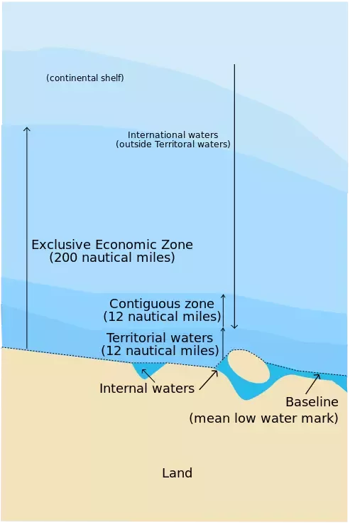
|